This blog covers travel suggestions and ideas by Keith and Heather Nicol. Most of our travels deal with outdoor activities like hiking,sea kayaking, cross country skiing, alpine skiing and other activities. We also enjoy traditional music and cultures. We have written over 800 articles in various magazines and newspapers. We are frequent contributors to Ski Trax and Saltscapes Magazines. Keith Nicol has also written 2 books and has a popular you tube channel http://www.youtube.com/user/k2nicol
by Keith and Heather Nicol When we go to Vancouver to visit friends and family we usually like to get out for hike while we are there. On a recent trip we decided to check out the Quarry Rock hike since it is fairly short but gives expansive views at the lookout bluff at the trail's end. To start the hike you need to drive to Deep Cove and find a parking spot. This can be a challenge on sunny weekends but we went midweek and found a free spot on Panorama Drive in front of Panorama Park. We walked down Panorama Drive and quickly found the access trail to Quarry Rock. The hike in is not long --our GPS showed about 3 km one way --but is a roller coaster of valleys so the trails winds up and down with lots of stairs and stream crossings with bridges. We had done this hike 10 years ago and we certainly didn't recall all those stairs but this means it is more strenuous than you might think. Our GPS showed an elevation gain of over 250 meters so people with mobility issues or families with young children might have trouble on this trail. The viewpoint at the end is a large rocky bluff which is a perfect place to have a snack and get a few pictures.-see picture below. Check it out on your next trip to Vancouver. See you on the trail.
On Thursday July 3 we decided to check out
Saratoga Beach Golf Course which is located near Saratoga Beach midway between
Campbell River and Courtenay, B.C.We had
arranged a tee time for 10 am and we had perfect golf weather. Saratoga Beach Golf Course is a 9 hole course
that is very walkable since the distance is around 2200 yards and the course is
quite flat. But don’t let the short distance fool you, there is still alot of
challenge to be had for all levels of golfers. The course consists of 4 par
3’s, 4 par 4’s and 1 pair 5 but the course is generally narrow with water
hazards that come into play on many holes.You need to be able to get the ball in the air and carry some distance
or else you will lose a few balls to the small ponds and creeks that flows
through the course. Last year we played this course and awarded it the most improved course in the Comox Valley and this year they are working on improving many of the tee boxes. This meant that we had to play on some temporary tee boxes on our round - actually this wasn't too bad since it shortened the holes - but General Manager Jordan Irwin told us the new tee boxes will be ready to go by July 11. We look forward to checking the course out again later in the summer to check them out.
Heather getting ready to tee off on number 1
Jordan told us that they get
most of their business from the local community but also from the Comox Valley and Campbell River. They have a Men's League which plays on Tuesday night and Sunday morning and a Women's League that goes |Tuesday morning and Wednesday night so if you want to meet some new golfers you can contact the clubhouse for more information. Also if you want a steal of a deal book a round on Mondays when 9 holes will cost you only $20.00 . Also if you have got young ones wanting to learn to play they can sign up for Junior Days on Thursdays from 2 to 4 pm. Saratoga Beach Golf Course has a small putting green and
a driving range as well as a small club house, food truck and pro shop. If you want to try
a challenging course that will reward the straight ball hitter then see:http://www.saratogabeachgolfclub.ca/for more information.
As you can see the picture above - the greens are in great shape
The fairways are narrow so this course rewards the straight ball hitter
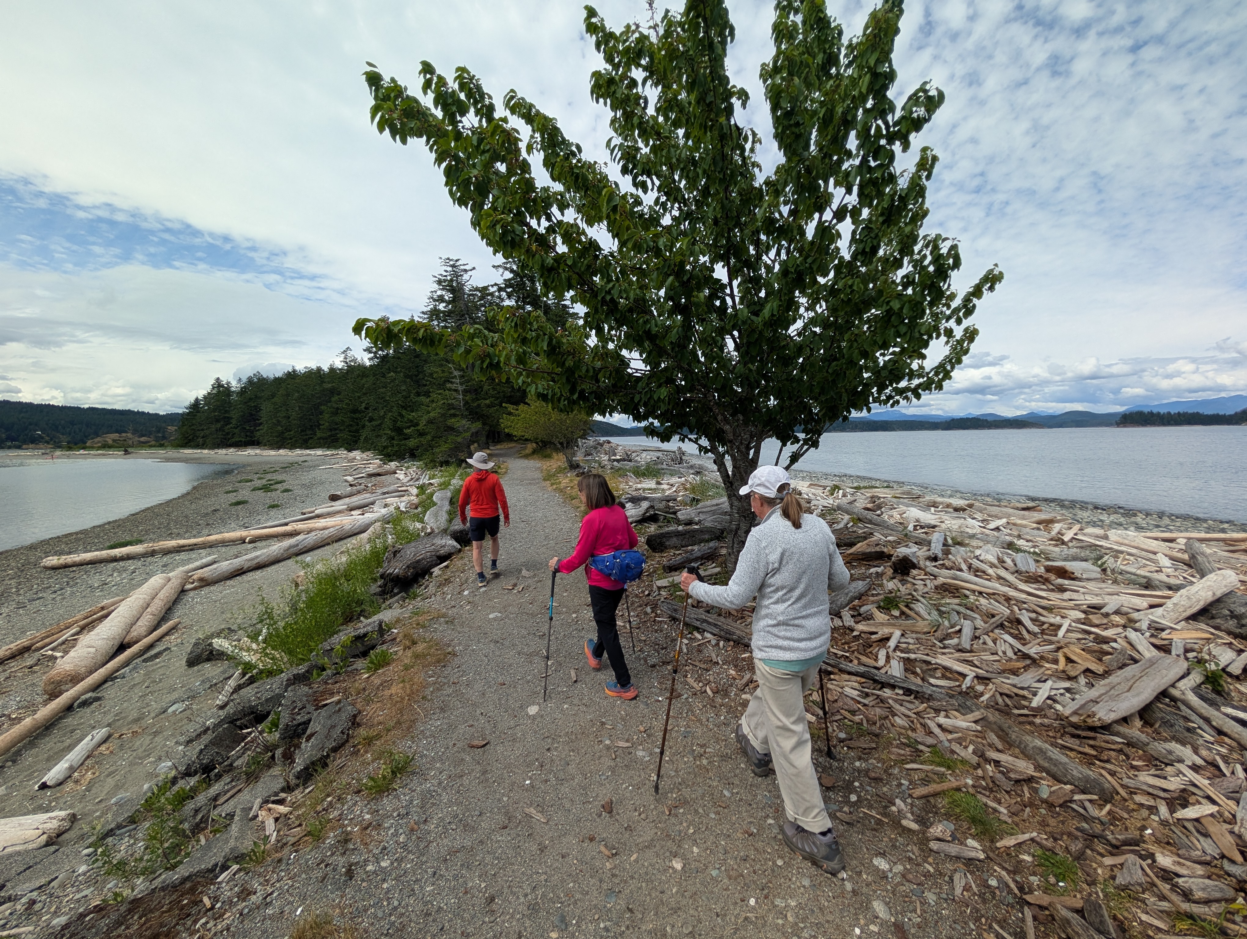
We don't get to Quadra Island very often even though it is just around the corner from the Comox Valley. So with a couple of friends we recently decided to check out some of the short hiking trails and do some exploring by car. We caught the 10 am crossing and were driving toward the Mudge Point lighthouse by 10:30 after a quick stop for coffee in Quathiaski Cove. We had hoped to do a coastal trail in the area but one of the people we ran into at the RV Park thought that it was not in great shape so we opted to do the Haskin Farm trail which friends had recommended to us. It features a nice walk though the tall trees and has an open area which we assume used to be the farmstead and then the trail gets steeper and descends to the ocean. Here you get scenic views of various islands and the mountains of the BC mainland. Our GPS showed a distance of about 3.5 km return and it took us about 1 hour to whole trip.
The Rebecca Spit Trail is a Don't Miss Hike!
By this time we were getting hungry so found a delightful picnic spot at Rebecca Spit overlooking Hariot Bay and then did a gem of a hike to the end of the spit. The trail is a suited to all ages since it is flat and very picturesque. It is just 2 km return and time taken will be determined how many pictures you take or how long you sit on the beach and enjoy the view. Our final hike for the day was one that headed inland and was much rougher than the first two with lots of roots and rocks with an elevation gain of about 100 m. The Hariot Ridge trail (1 km one way) provides glimpses of the ocean back toward Campbell River but we thought it would give better views to the East. Perhaps trees have grown up but next time we want to try a hike that gives good vistas back toward Rebecca Spit. All of these trails plus many more are listed on the Quadra Island map that we picked up on the ferry. Be sure to get one because it lists many other attractions on Quadra Island and even has the ferry schedule on it. We had time for quick snack at Quathiaski Cove before we boarded the 4:00 pm ferry which put us back in the Comox Valley in time for dinner. We had just scratched the surface of hikes to do on Quadra since the map we used listed over dozen other options. See you on the trail.
The so called Medicine Bowls and on the Brown's River near Courtenay
offer another way to see this river which is normally hard to access. A
previous blog this spring discussed the accessing the water falls lower
down on the Brown's River from Piercy Road. If you missed that and want
more info - here it is- https://keithnicol.blogspot.com/2025/06/waterfalls-on-browns-river-near.html.
The Medicine Bowls are also well worth a visit and like we have
discussed in other blogs-if you can ride a bike there instead of hiking
then count us in. In this case the river has carved a series of bowls
and waterfalls in the rock but actually swimming here should be done
carefully as a monument near the site records the deaths of 2 teen age
friends that died here in the summer of 2001.
Biking up the access road
To
access the Medicine Bowls simply type in "Medicine Bowls Parking" in
google maps and it will lead to a large parking lot just off of the
Forbidden Plateau Road. Depending on where you live in the Comox Valley
the actual distance will vary but from our house it is about 15 km (1
way). From there the trail- actually a road - heads uphill and we opted
to bring our bikes since the whole route appeared to be easy to do on a
mountain bike. The trail is less than 2 km 1 way so if you don't want to
bike it is an easy walk to the access trails down to the river. Once up
the main trail we chained our bikes to a tree and then headed down
several different trails that access various parts of the Medicine
Bowls. These trails are steep and some use ropes to descend so will not
be suited to young children or those people not comfortable on steep
slopes or using the attached ropes. We went on a dry day but the steep
trails accessing the river would likely be very slippery in wet
conditions. This is a very scenic spot but use care around the river
since in places the mossy rocks are very slippery. See you on the trail.
Be careful along the river's edge since there are lots of areas of slippery moss
The
Evergreen Bike Group has rides on Mondays and Wednesdays
and is a great way to meet cyclists and explore the country roads and
trails of
the Comox Valley and beyond. The Evergreen group is open to cyclists over 55 years of
age and the
group uses mix of electric , hybrid and road bikes. The rides on Mondays tend to be longer and it
gives us a chance to explore places like Denman, Hornby and Quadra Islands as well as
rides in Campbell River and Parksville. For instance, on Monday June 16 twenty cyclists headed to Powell River to check out the cycling in that community. On Wednesday morning the rides tend to be in
the Comox Valley and run for 2 to 2.5 hours in length. If you are interested in
finding out more about this cycling group contact Ernie at: ejkimball62@gmail.comThe pictures below are of the group cycling in Powell River and along the waterfront in Royston. See you on the trail.
We always would rather bike to a scenic viewpoint or waterfall if we can
since biking is usually so much faster especially on the descent. So
when a friend mentioned a waterfall on the Trent River that they saw
from a black diamond mountain bike trail at Cumberland we decided to
look into how we could get there without the skill needed to bike a black diamond bike trail. Fortunately with the Trailforks app you can
sometimes figure out another way to get to a location using easier
trails. It didn't take long to put together a route that would basically
involve logging roads or easy green trails since one of group had an
old hardtail bike and little experience biking on some of Cumberland's
more difficult trails. We started at the main bike parking lot in
Cumberland and once on the trails headed to Davis Lake Main East to Trent River Main. We
ascended up Trent River Main to Trent Canyon Access Road (these roads are marked on trailforks). We turned
left on that road and followed it to the Black Diamond- Trent Canyon
Trail Lower and after leaving our bikes at the top of the trail we
walked down this trail for a few minutes to a nice waterfall. With
snowmelt there is currently a nice amount of water flowing and after
getting some pictures we walked back to our bikes and proceeded down Trent River Main to Allen Lake Main then to Allen Lake North to Shaker Road and then down Davis Lake Main West to the
car park. Total distance was about 17.5 km and it took 1 hour and 45
minutes to complete. Note almost all of the trails we rode on were wide logging roads except part of Allen Lake North. Be sure to download the Trailforks app if you want
to explore any of the many multi use trails at Cumberland. Remember
those trails are not just for avid mountain bikers- many trail runners
and hikers also use those trails. See you on the trail.
We recently decided to check out a waterfall and trails leading to the Brown's River which is normally fairly inaccessible. This hike is very short - less than 1 km 1 way and starts at the Komoks Treaty Lands and Tribal Park and Wildwood Interpretative Forest Park parking area. This is on Piercy Road and on a hot day you can see lots of cars parked along the road for some distance since the informal parking area is very small. We initially thought all these people were walking in the Wildwood trails but then found out that in fact they were heading to the Brown' s River with its eroded pools and small waterfalls which are nice for cooling off in the summer.
A falls on the Brown's River
So instead of heading into the woods into the Wildwood trails, walk down
the powerline on the southside of the road and shortly you will come to
a side trail heading to the right. Follow it into the forest and soon
will be looking over the Brown's River their are many short trails which
descend to the river and now with snowmelt the river is bubbling right along.
Some of these trails are steep and have ropes to aid in your descent or
ascent. The descents will not be suited to all people so if you have
young children or have mobility issues you might have to be content to
walk along the trail at the top which still gives good views of the
river. This is a fun trail to explore and we want to come back in the
summer to check it out for swimming when the river is flowing more
slowly. This trail looks like it could be quite muddy and very slippery
if it is raining out so it best to go in the late spring , summer and
early fall after a day period. See you on the trail.
Golf
is popular in the Comox Valley with many
courses to test your skills but if you want to try a fine little course
that
allows you to play 9 holes for less than $20 then check out
Mulligans
Golf Course.Where
else can you play 9 holes for golf for just $16 (before 8:30 am and after 3:00 pm) and this goes up to $18.00 (between 8:00 am and 3:00 pm). And these low rates have stayed the same for the past few years.
Keith teeing off on hole 2 with the Beaufort Range Mountains in the background
They offer an executive course which means
there are mostly par 3’s with some par 4’s and the longest hole is 337 yards.
Total length from the blue tees is 1763 yards which is about a mile so it is
also easy to walk for many people from younger children to older adults. But
just because it is short doesn’t mean it is easy. There is water on 7 of the 9
holes and many strategically placed sand traps so depending on where the pin is
placed, making par can be a real
challenge. The course also gives scenic views of the Beaufort Range of
Mountains and has been landscaped to create undulations and mounds which add to
the layout of the course. When we played the course on June 10 it was nice and green as you can see in the photos.
Keith chipping on hole 6- thank goodness I cleared the water on my second shot
In addition to a small clubhouse with an
outdoor patio , there is a driving range, a putting green and a sand trap practice
area where I need to spend more time. The driving range is another bargain
since a bucket of balls is just $3.75 ! The manager Jesse Polito told us that the busiest times are usually between 9 am and 2 pm and they have a special deal for groups of 4. One of the group will get a free round! Also if you buy a bucket of balls between May 18 to May 25 you a second bucket free. Remember this for next year. Jesse also told us they prepare much of the food on site and have beer for $4.00 on tap. It is hard to say no to all those deals. Mulligans
is located right outside of Courtenay and it took us about 90 minutes to play 9
holes. For more information see: http://mulligansgolfcourse.com/or phone 250-338-2440. This course is ideal
for families or friends wanting to meet for a couple of hours of enjoyable
golf. See you on the course.
Heather putting on hole 8- the greens were in great shape
Cheakamus Lake is a scenic lake that is accessed by a fairly flat trail so is accessible by a wide variety of people. On our recent hike there we saw families with young children all the way to seniors enjoying this hike. Cheakamus Lake is on the doorstep of Whistler so it can be crowded -- in fact many times of the year you need a pass to park at the trailhead so check the BC parks website for details. The parking passes are free but book up quickly. The trailhead is roughly 7 km up a gravel road and when we did the hike on June 6 with our daughter Kristie and her partner Eric the road had been freshly graded. Evidently when Kristie and Eric have done the hike other times the road has been rougher with potholes but you don't need a 4 wheel drive to get there.
The first 4 km wind through tall trees which made our hike cool and you get glimpses of Cheakamus Creek in the valley below. The trail then extends another 4 km along the northern lake shore and fortunately much of this part of the trail is shaded as well. There are several campsites along the lake and these can be reserved through BC Parks. The trail is easy to follow with only a few rocky and rooty sections and we saw several trail runners and mountain bikers making good time on the trail. There were also some muddy sections but they will likely dry out through the summer. It is best to wear sturdy footwear although we saw people hiking in sandals . Cheakamus Lake itself is very scenic with a variety of snow capped mountains ringing the far end of the lake. We had our lunch at the first camping area (there are washrooms) before doing the 4 km hike along the lake shore to Singing Creek where the trail ends. Use an app like AllTrails or Trailforks for specific driving directions to the trailhead. This hike is well worth the effort and gets a 4.7 out of 5 on AllTrails . Say no more.
Keith , Heather, Kristie and Eric at the trail end
Campbell River is fortunate to have a varied collection of scenic islands in its vicinity as well as a rich marine ecosystem with many types of whales, seals, sea lions and various sea birds. In the past we have taken whale watching tours in this area but on June 1 we opted for a different experience and joined the Campbell River Museum for a tour of some of Desolation Sound with a stop at historic Refuge Cove on
West Redonda Island. This tour is a partnership with the museum and Campbell River Whale Watching and Adventure Tours (CRWW) which is an award winning boat tour company based in Campbell River
(https://campbellriverwhalewatching.com/). The Campbell River Museum runs several tours through the summer with a historic interpretation with CRWW and you can check out their web site for details for other trips into various parts of the Discovery Islands (https://crmuseum.ca/)These trips book up quickly so check out their offerings and plan ahead so you don't miss out.
Boarding the Tenacious III
We had nice sunny weather for our 4 hour afternoon trip but we also had strong outflow NW winds which were forecast to gust to 25 knots . Our Captain told us that anyone sitting in the upper deck might get wet especially for the first part of the trip. Fortunately there was room for everyone in the enclosed cabin of the Tenacious III .That is where our museum guide Sandra Mulligan provided much of the
information about what we were seeing from a historical perspective. Most of the 20 passengers were from the local area including Nanoose Bay, Royston, Comox and Courtenay but we did have one person from Texas who was here to escape the heat of the southern US. Sandra gave us reading lists about the areas we would visit as well as a map which she kept updating while the afternoon unfolded.
Our Museum Host - Sandra - provided lots of information about the history of this area
After leaving Campbell River our tour passed by the southern end of Quadra Island and Sandra pointed out Cape Mudge and told us to be sure to visit the First Nations Nuyumbalees Cultural Centre there. Our first stop was at Twin Islands which is just off of Cortes Island and we
got a chance to see a historic house/lodge with a fascinating history .
According to Sandra it was initially built by Americans Dick and Ethel
Andrews in 1936. Apparently they had made lots of money in Japan but
could see hostilities on the horizon so wanted an out of the way place
with arable land, fishing, fresh water and a good moorage. Twin Islands is certainly out of the way since it is an island with no
road access!! Sandra thought at one time it was the most expensive house
in all of BC!! The lodge has since changed hands a couple of
times and the current owner is Mark Torrance who is an entrepreneur from Seattle.
Visiting historic Refuge Cove-was a real highlight Our next stop was Refuge Cove on West Redonda Island which has been a
focal point in this area since 1890 when a store was first opened. We
were especially keen to see Refuge Cove since we had visited here in the
late 1970's when friends from Vancouver moved to help run the historic
store. At that time Bonnie and Colin Robertson had just given birth to
Lucy and we visited them for several days in the
spring of 1979. And who should we meet in the store on this trip but
Lucy who now runs the store since her parents have retired! Refuge Cove
is a hidden gem and the only way to get here is by boat.
Heather and Lucy at the store in Refuge Cove
After an enjoyable reunion with Lucy and a story from Sandra about a
long time Refuge Cove resident with a cougar in his house we then headed
across Desolation Sound to Portage Cove and then to Galley Bay. Both
have a long history of settlement and at one time held a much larger
population than they do now. But with the boom and bust of logging and
fishing along this coast the area now mainly is used by summer
cottagers. Desolation Sound got its name from Capt George Vancouver in
1792 since he thought it looked "gloomy and forlorn" but now it is a
very popular destination for boaters in the summer. Sandra told us
about the parties people used to hold in the houses in Galley Bay that
would attract people from Cortes Island and Refuge Cove. "They would row
over, have a grand party and then row back the next day. A distance of
10-15 km one way!" But now it was time to head back to Campbell River so
we backtracked leaving behind scenic Desolation Sound with its snow
capped mountains . We reflected on the varied human history that has
lived along these rocky islands and wooded hillsides that are mostly
only accessible by boat. A big thanks to Sandra and the crew for giving
us a glimpse of the fascinating history found along these shores.
Although we had travelled over 100 km on our trip we realized we had
just scratched the surface of seeing the many islands and waterways that
are found in the Discovery
Islands. We can't wait to check out another Campbell River Museum Boat Tour next year. Here is a short video of our trip. Check it out
We love heading to Hornby Island and so when our daughter was visiting recently from Vancouver for Mother's day we decided an impromptu trip was in order, especially since our daughter had never been there. We caught the 900 am ferry from Buckley Bay and that got us on to Hornby by 1000 am given that we had to drive across Denman Island and then catch the 10 minute ferry crossing to Hornby Island. Since our daughter likes to hike we first did the hike at Helliwell Park and it was perfect with the blue water below the cliffs and spring temperatures that were ideal for walking (see picture below). After completing that 4 km hike we headed to Tribune Bay where we had lunch on beach front log and since the tide was low it gave a huge area of beach to explore.
After lunch we headed to the shoreline at Sandpiper Bay which is totally
different from sandy Tribune Bay with its tilted sedimentary rocks and
stray boulders dotting the inter-tidal zone. Then it was on to Ford's
Cover and the wave sculpted and pitted sandstone of the shore line in
that location. We ended the day with another hike at the Middle Bench
trail and this is another stellar hike with fabulous views. It is under 2
km in length so doable by many people...but be aware it is along a
cliff edge so watch your footing and keep small children close by. We
caught the 400 pm ferry off of Hornby which put us back in Courtenay by
5:15 pm just in time for dinner. And a bonus of a trip in the spring is
that there are few people around - unlike the crowds in the summer time.
Check it out.
Tribune Bay has as huge sandy beach --especially at low tide
The Glacier Grove Disc Golf course has just opened this spring and is a great addition to the Comox Valley Disc Golf scene. It is located at the back of the Glacier Gardens Arena at 1399 Military Row. The tee boxes are great and although there is no map of each hole or a general map of the course it is pretty intuitive to follow. Be aware that it parallels a walking trail in parts so be aware of where errant discs may fly and either wait until the foot traffic has passed or yell Fore.
Heather getting ready to putt
The course is 9 holes and has regular disc golf baskets. The course is quite wooded but with openings to allow the accurate disc golfer a challenge. The course more or less heads into the woods and so when it ends you need to walk back to the starting point. Perhaps the idea is that with another 9 holes it will bring the golfer back to the parking lot? We liked the fact that the holes were relatively short which makes it a good beginner course but we think all disc golfers will find it a challenging course due to the close tree spacing on many holes. This is a great addition to the local disc golf scene. Thanks to those who created it.
We always
love doing the so called “Pub to Pub” trail which is roughly half way between
Campbell River and Courtenay since is a scenic trail with both river and
ocean/beach views. We hadn’t done the trail for a few months since last fall and so we decided to walk on Friday May 2 with some xc ski
buddies from Mt Washington who had not done the trail before. The
trail gets its name from the fact that 2
pubs were located close to the start and end point of the trail but now
these
“pubs” are no longer there. Since the trail is just 3.5 km (1 way) it is
suited
to a variety of options. If you have young children or walkers that
would find
7 km too long a hike, you could park a car at each end and just make the
1 way
trip. You can see from the photo below that the trail surface is well
maintained and is generally flat so is walkable for just about all ages.
To get
there from Courtenay drive north on Highway 19A and keep an eye out for the
Oyster River bridge since you want to turn right on the next road (Glenmore
Road).Then travel one roughly 1 block
and then turn left on Regent and look for a parking lot with a sign Oyster
River Nature Park. The parking lot coordinates are 49. 52.232 N and 125
07.616 W. There is parking for several cars but this area is popular so
we try to go mid week to be able to get a spot. There are a few forks in the
trail but bear to the left and you should be fine. After about 1 km you reach the ocean and
from there you follow the Jack Hames Trail to Salmon Point. You can walk the
trail in either direction although we tend to walk it south to north most of
the time. On this day we were treated to some dramatic skies and we had lunch on driftwood logs part along where we had a fabulous view of ocean and mountains of the BC in the distance. Check this trail out of you haven't done it before. See you on the trail.
The
Comox Bluffs are along the north side of Comox Lake and there is an ecological reserve
there to protect the unusual plant life that exists in this dry rocky sun
drenched area. Trees like Arbutus and shrubs like hairy Manzanita are common
along this area where as they are pretty rare in the rain forest environment of
the Comox Valley. We hadn’t been to this lookout for a couple of years and we hoped to see some wildflowers which bloom here early in the spring.
The viewpoint overlooking Comox Lake is just a 25 minute walk from the parking lot
This
trail starts at a small parking lot at 49 38.477 N 125 06.256 W on the left
hand side of the road a few hundred meters past the bridge the crosses the
Puntledge River where it empties out of Comox Lake. This route is called the Tomato Creek trail
and it leads to a lookout which gives fine views of Comox Lake and is
surrounded by the rare plants of the Ecological Reserve. It can be reached in
just over 1.2 km (25 minute walk one way ).Some
of the many flowers that bloom here were out although if you come at various
times in the spring you will likely see avariety of different flowers in bloom. We saw lots of sea blush out on
this visit.
Sea Blush was out in bloom in mid April on our most recent trip to Comox Bluffs
A longer
trail continues from the lookout and it traverses the entire Ecological Reserve
and ends up at the main logging road which you can then follow back to your
car. Be aware that logging trucks may be using this road and it can be dusty so
you also can return back via the same trail rather that do a loop.This longer route is about 5.5 km and takes
about 2 hours. But the shorter hike to the lookout would suit people families that want a shorter hike.Just
be aware that the trail is hard to find
in some places and it does have forks which makes route finding abit
challenging. In fact we ran into a couple that was off route trying to
reach the Bluffs and they followed us to the Lookout. The full route can
be found on AllTrails and is under the name
“Tony’s and Tomato Creek Loop”. If you use this app route finding should
be
easier. For more info see: https://www.alltrails.com/
Vancouver and Victoria are well known for their cherry trees
in bloom in the spring and although the Comox Valley does not have the number
of trees of these bigger centres they do have some trees worth checking out.
One of our favourite streets to view every spring is Anna Place in Courtenay which not only
has many well established trees in bloom lining the street but it also has a
superb view of the Comox Glacier as you can see in the picture below. Another
tree that is very impressive is at the intersection of 14th and
Cumberland in Courtenay. If readers have other favourite cherry trees in the Comox Valley let us
know where they are.
It was a sad day when we cleaned out our ski
locker at Raven Lodge on Sunday, April 13 to end the 2025 cross country ski
season. Raven Lodge is the base of operations of cross country skiing and snow
shoeing at Mount Washington near Courtenay, B.C on Vancouver Island. Given all the early snow that the resort had the cross country ski trails were almost fully open by Christmas. That was lucky since January and February turned out to be drier than normal but we already had a good base. March arrived with lots more snow and so the season will end with close to 2 meters of snow on the ground. Overall grooming was great this year and the resort did a great job keeping the popular Park trails open even as snow was disappearing at key stream crossings through the last couple of weeks.
We had some great times on the trails with visitors from across the country
So next year if you have thought about
trying cross country skiing or snowshoeing then check out Raven Lodge at Mount
Washington. They have over 50 km of trail groomed for skating and classic
skiing as well as many snowshoe trails. Raven Lodge has great mountain views
and inside you can have a bite to eat, book rentals and lessons, buy day
tickets and even have a sauna.Lets hope
next winter brings more snow and continued great skiing to Mount
Washington.I even got in a xc ski on the last weekend to Lake Helen Mackenzie and it was perfect for skating on (see below) . For more information see: https://www.mountwashington.ca/
On Friday, April 11 we decided to take a
break from skiing at Mount Washington to check the fawn lilies and other wildflowers
along the Tsolum River in Courtenay. The last couple of weeks have seen some mixed weather with rain and cool temperatures some days but more seasonable temperatures on other days so we weren't sure quite what to expect.
Fawn Lilies are delicate spring wildflowers
There were carpets of fawn lilies and
trilliums in bloom along the trails which really brightened up our walk. These
trails are located behind the Exhibition Grounds off of Headquarters Road in
Courtenay and there is lots of parking. Take the main access trail (really a
road) toward the river and we found many clusters of fawn lilies on the trails
to the right near the river. You don’t need to walk very far before you see the flowers in
bloom along the trail and under the trees.
A Trillium surrounded by Fawn Lilies
We are not sure how long they will last but
if like early spring flowers check out this area and don’t forget to bring your
camera. If you are into pictures you might want to bring a tripod and something
to kneel on since the carpets of flowers are best photographed low to the
ground and the ground can be wet. Another bonus of our walk was seeing a couple of great horned owls. They were quite a distance from the trail and we only saw them since there were several photographers with long telephoto lenses taking photos of them as we passed by. There are other song birds in the area and in the past we have seen Pileated woodpeckers at this time of year. Binoculars might not go astray...see you on the trail.
Mount Washington Ski Resort started early and is ending late - April 13 , 2025 is its closing date. But next week people who have never skied before can try the sport for FREE. That is right FREE!!
By signing up for a Discover Skiing Lesson you can get gear, lesson and lift or trail ticket for free. So if you have never tried xc or alpine skiing here is your chance. Mt Washington runs a similar programme in the early winter but often the weather is stormy and cold at that time of year. Now you can enjoy spring sun and warm temperatures (hopefully) while you learn to ski. For more info see: https://www.mountwashington.ca/play/groups-events/events.html and scroll down to Discovery Days - Beginners FREE Lesson, Rental and Ticket This programme runs from March 31 to April 4. Be sure to check it out.
The Comox Valley has seen fog come and go
over the past several days but when it is cloudy and grey down in the valley it
might be bright and sunny at Mount Washington. That is how it was when we have
been cross country skiing a couple of times this week and I expect we will see more
ofthis weather over the next week or
so.So it pays to check out the web cams
at Mount Washington Ski Resort since while it is cold and foggy in town it might
be bright and sunny at Mount Washington.This is caused by ridges of high pressure which trap cloud and fog close
to the surface but as you go up in elevation you break through the cloud giving
great conditions on the mountain. So if the fog and chilly temperatures are
getting you down, head for the hills and you might find it is alot sunnier and maybe
even warmer than in town.And the views
are spectacular with layers of cloud and fog below and snowy mountains rising
above them (see photos below). To check out the web cams at Mount Washington
have a look at: https://www.mountwashington.ca/


.jpg)
.jpg)
.jpg)


.jpg)


.JPG)
.JPG)
.JPG)


%20-%20Copy.JPG)

.jpg)
.jpg)
.jpg)
.jpg)


.jpg)
.jpg)

.JPG)
.JPG)
.JPG)


