By Keith and Heather Nicol
 |
| Kristie and Heather just above one of the low eroding cliffs |
While kayaking to
Tree Island a few days earlier we had noted people walking along the shore just
north of our launch point. So when our daughter Kristie and her boyfriend Eric
came to visit we decided to check it out for July 1, Canada Day! We found a
small parking lot on the ocean side of the road just north of the community of
Union Bay which is 14 km south of Courtenay on the coastal highway. For those
handy with a GPS the coordinates for the parking lot are: 49 35.250 N and 124
53.210 W. There are prominent signs indicating private property so enter at
your own risk. No sooner had we started walking than we ran into people who knew
this area well and they explained that it is the remains of a coal “washing”
station when this area was an active coal port. Coal was brought here to be
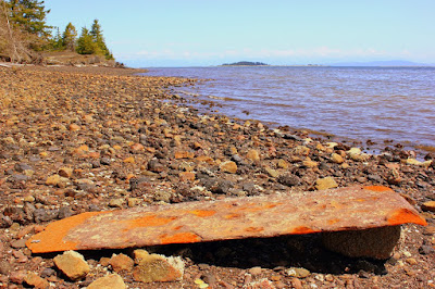
loaded onto ships and you can see the remains of wharves and rusting equipment
from the processing operations which extended from the 1880’s to the 1960’s.
“This area is all fill and is eroding away at fast rate. I would say it has
eroded 20-30 meters in the past 20 years” one person told us.
 |
| Part of the industrial debris left from the coal port - Tree Island in the distance |
So this is not a
pristine coastal walk but it does provides fine views of Tree Island and Denman
Island and the “historic industrial” land uses are being revegetated. We walked a loop that lead along the ocean
and then headed back along “Washer” or Hart Creek. There are many side trails
which we didn’t explore on this trip but we liked the clearings and open forest
that is not common in this part of coastal Vancouver Island. Allow about 45 –
60 minutes to do the mostly level 2.4 km walk depending on how long you linger
along the way. Don’t get too close to edge of the “cliffs” which are actively
eroding and respect the signs that are posted.
 |
| Walking back along Washer Creek |
No comments:
Post a Comment